
Failu:Mauritius (+claim islands).svg

Size of this PNG preview of this SVG file: 500 × 463 pixels. Ofifi resolutions: 259 × 240 pixels | 518 × 480 pixels | 829 × 768 pixels | 1,106 × 1,024 pixels | 2,212 × 2,048 pixels.
Failu eyi atata (SVG file, nominally 500 × 463 pixels, file size: 1.41 MB)
.svg)
Nkana-ngwook
| Ike îkupbe |
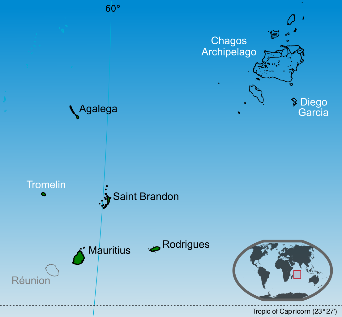
English: Islands of the Republic of Mauritius labelled in black. Mauritius claim Tromelin island claim from France and the Chagos Archipelago from the United Kingdom. |
| Usen-onyan̄ | |
| Ere înan̄abe |
Ubọk-ikwaan̄ kan̄ This vector image includes elements that have been taken or adapted from this file: This vector image includes elements that have been taken or adapted from this file: This vector image includes elements that have been taken or adapted from this file: This vector image includes elements that have been taken or adapted from this file: This vector image includes elements that have been taken or adapted from this file: This vector image includes elements that have been taken or adapted from this file: |
| Ogwu ògege | Yashveer Poonit |
| Other versions | Macedonian version |
_mk.svg)
Inyinyi unye
I, the copyright holder of this work, hereby publish it under the following license:
Unye-ngon eyi failu yi ìre eyi Creative Commons Attribution-Share Alike 3.0 Unported license.
- Owu môkọt:
- icheche ikana – ichichibi, ichon mè iria inu yi isibi
- igwugwugwa – inwenwene ubọk-ikwaan̄ yi itap me ike oweekbe
- Mè ire ochieek irọrọ ikechi:
- itọn̄ yi – Owu òkaan̄ inyinyi itọn̄ ògbegbe, inyi ugọbọ òkisi lek license ya, mè itumu si mè ìre mînwene inu geege. Owu môkọt irọ ikeya me oniin̄ geelek òsisibi inu, ire, karọ me oniin̄ òborọ ibe ebi ene ekekeek ebe ke ogwukaan̄ îrọ owu inye mè ìyaka ire ke îrọ inu owu osabe irọ inye.
- che ikeya si – Ire okpọk igwugwa, inwene, mè ìre inen̄e inu yi isa irọ ofifi inu, owu òkaan̄ icheche inu ya orọbe me same or compatible licenseike îrebe me eyi adasi ya.
Mfufuk failu
Keme me lek usen-onyan̄/mgbọ inyi òmun̄ failu ike îkupbe me mgbọ ya.
| Usen-oyan̄/Mgbọ | Asabọn-ogugo | Okike | Òsikwaan̄ | Tumu ikọ folek | |
|---|---|---|---|---|---|
| eyi mgbọ keyi | 02:24, 14 Julai 2014 | | 500 × 463 (1.41 MB) | Yash400 | use accurate map of Chagos |
| 13:59, 20 Jenuwari 2014 |  | 500 × 463 (1.37 MB) | Palosirkka | larger nominal size | |
| 19:50, 19 Jenuwari 2014 |  | 255 × 236 (1.37 MB) | Yash400 | remove black lines | |
| 19:25, 19 Jenuwari 2014 |  | 257 × 238 (1.37 MB) | Yash400 | change color | |
| 19:08, 20 Nọvemba 2013 |  | 572 × 530 (1.41 MB) | Yash400 | User created page with UploadWizard |
Ikwaan̄ failu osibe
The following page uses this file:
Inu esabe failu irọ me otutuuk ere
Wiki kechi ekisa failu yi irọ inu:
- Inu esabe irọ me af.wikipedia.org
- Inu esabe irọ me ar.wikipedia.org
- Inu esabe irọ me avk.wikipedia.org
- Inu esabe irọ me bh.wikipedia.org
- Inu esabe irọ me bn.wikipedia.org
- Inu esabe irọ me br.wikipedia.org
- Inu esabe irọ me ca.wikipedia.org
- Inu esabe irọ me ceb.wikipedia.org
- Inu esabe irọ me ckb.wikipedia.org
- Inu esabe irọ me de.wikipedia.org
- Inu esabe irọ me diq.wikipedia.org
- Inu esabe irọ me dty.wikipedia.org
- Inu esabe irọ me en.wikipedia.org
- Inu esabe irọ me es.wikipedia.org
- Inu esabe irọ me eu.wikipedia.org
- Inu esabe irọ me fa.wikipedia.org
- Inu esabe irọ me fi.wikipedia.org
- Inu esabe irọ me frp.wikipedia.org
- Inu esabe irọ me fr.wikipedia.org
- Inu esabe irọ me fr.wikinews.org
- Inu esabe irọ me gl.wikipedia.org
- Inu esabe irọ me gu.wikipedia.org
- Inu esabe irọ me ia.wikipedia.org
- Inu esabe irọ me id.wikipedia.org
- Inu esabe irọ me ilo.wikipedia.org
- Inu esabe irọ me incubator.wikimedia.org
- Inu esabe irọ me io.wikipedia.org
- Inu esabe irọ me ja.wikipedia.org
Kpọ ebi kè ofifi inu esabe failu yi irọ.
.svg)
.svg)