
Failu:Comoros (orthographic projection).svg

Size of this PNG preview of this SVG file: 550 × 550 pixels. Ofifi resolutions: 240 × 240 pixels | 480 × 480 pixels | 768 × 768 pixels | 1,024 × 1,024 pixels | 2,048 × 2,048 pixels.
Failu eyi atata (SVG file, nominally 550 × 550 pixels, file size: 185 KB)
⧼filedescMrmaitreeemeechana.3720100955361⧽
| Ike îkupbe |
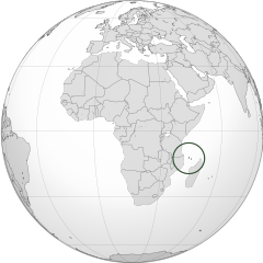
English: Orthographic map of the Comoros |
| Usen-onyan̄ | |
| Ere înan̄abe | Ubọk-ikwaan̄ kan̄ |
| Ogwu ògege | Spesh531 |
| Other versions |
Derivative works of this file: Africa (orthographic projection).svg .svg) |
.svg)
.svg)
.svg)
.svg)
.svg)
.svg)
.svg)
.svg)
.svg)
.svg)
.svg)
.svg)
.svg)
.svg)
.svg)
.svg)
.svg)
.svg)
.svg)
.svg)
.svg)
.svg)
.svg)
.svg)
.svg)
.svg)
.svg)
.svg)
.svg)
.svg)
.svg)
.svg)
.svg)
.svg)
.svg)
.svg)
.svg)
.svg)
.svg)
.svg)
.svg)
.svg)
.svg)
.svg)
.svg)
.svg)
.svg)
.svg)
.svg)
.svg)
.svg)
.svg)
.svg)
.svg)
.svg)
.svg)
.svg)
.svg)
.svg)
.svg)
.svg)
.svg)
.svg)
.svg)
.svg)
.svg)
.svg)
.svg)
.svg)
.svg)
.svg)
.svg)
.svg)

.svg)

.svg)

.svg)
.svg)
.svg)
.svg)
.svg)
.svg)
.svg)


.svg)
.svg)
.svg)
.svg)
.svg)
.svg)
.svg)

.svg)
.svg)
.svg)
.svg)
.svg)
.svg)
.svg)
.svg)
.svg)
.svg)

.svg)
.svg)
.svg)
.svg)
.svg)
.svg)
.svg)
_without_national_boundaries.svg)
.svg)
.svg)
.svg)
.svg)
.svg)
.svg)

.svg)
.svg)
.png)
.svg)
.svg)
.svg)
.svg)

.svg)
.svg)
.svg)
.svg)
.svg)
.svg)
.svg)
.svg)
.svg)
.svg)
.svg)

.svg)
.svg)
.svg)
.svg)
.svg)
.svg)
.svg)
.svg)
.svg)

.svg)
.svg)

.svg)
.svg)
.svg)
.svg)
.svg)
.svg)
.svg)
.svg)
.svg)
.svg)
.svg)
.svg)
.svg)
.svg)
.svg)
.svg)
.svg)
.svg)
.svg)
.svg)
.svg)
.svg)
.svg)
.svg)
.svg)
.svg)
.svg)
_-_Crimea_disputed.svg)
.svg)
.svg)
.svg)
.svg)
.svg)
.svg)
.svg)
.svg)
.svg)
.svg)
.svg)
_political.svg)
.svg)
.svg)
.svg)
.svg)
_-_Crimea_disputed_-_no_borders.svg)
.svg)
.svg)
.svg)
.svg)
.svg)
.svg)
.svg)
.svg)
.svg)
.svg)
.svg)

.svg)
.svg)
.svg)

.png)
.svg)
.svg)
.svg)
.svg)
.svg)
.svg)
.svg)
.svg)
.svg)
.svg)
.svg)
.svg)
.svg)
.svg)
.svg)
.svg)
.svg)
.svg)
.svg)
.svg)
.svg)
.svg)
.svg)
.svg)
.svg)
.svg)
.svg)
.svg)
.svg)
.svg)
.svg)
.svg)
.svg)
.svg)
.png)
.svg)
.svg)
.svg)
_(orthographic_projection).png)
.svg)
| Camera location | | View this and other nearby images on: OpenStreetMap |
|---|
.svg¶ms=000.000000_N_0015.000000_E_globe:Earth_type:camera_type:satellite_&language=ann)
Inyinyi unye
I, the copyright holder of this work, hereby publish it under the following licenses:
Unye-ngon eyi failu yi ìre eyi Creative Commons Attribution-Share Alike 3.0 Unported license.
- Owu môkọt:
- icheche ikana – ichichibi, ichon mè iria inu yi isibi
- igwugwugwa – inwenwene ubọk-ikwaan̄ yi itap me ike oweekbe
- Mè ire ochieek irọrọ ikechi:
- itọn̄ yi – Owu òkaan̄ inyinyi itọn̄ ògbegbe, inyi ugọbọ òkisi lek license ya, mè itumu si mè ìre mînwene inu geege. Owu môkọt irọ ikeya me oniin̄ geelek òsisibi inu, ire, karọ me oniin̄ òborọ ibe ebi ene ekekeek ebe ke ogwukaan̄ îrọ owu inye mè ìyaka ire ke îrọ inu owu osabe irọ inye.
- che ikeya si – Ire okpọk igwugwa, inwene, mè ìre inen̄e inu yi isa irọ ofifi inu, owu òkaan̄ icheche inu ya orọbe me same or compatible licenseike îrebe me eyi adasi ya.

|
Mînyi unye ichichibi, icheche mè/mè ìre inwenwene ekwu yi igọọk me lek nchieek GNU Free Documentation License, Òsolek 1.2 mè ìre eyi mgburudun̄ eyi Free Software Foundation egonbe; with no Invariant Sections, kpunu inu-nge eyi Isi ikpa, kpunu inu-nge eyi udun̄ ikpa. Mîtap copy of license yi me agan̄ ekigwen GNU Free Documentation License. |
Owu môkọt igobo license òneme owu.
Mfufuk failu
Keme me lek usen-onyan̄/mgbọ inyi òmun̄ failu ike îkupbe me mgbọ ya.
| Usen-oyan̄/Mgbọ | Asabọn-ogugo | Okike | Òsikwaan̄ | Tumu ikọ folek | |
|---|---|---|---|---|---|
| eyi mgbọ keyi | 16:28, 29 Jûun 2012 | | 550 × 550 (185 KB) | Spesh531 | == {{int:filedesc}} == {{Information |Description={{en|1=Orthographic map of the Comoros}} |Source={{own}} |Author=Spesh531 |Date=2012-06-29 |Permission= |other_versions={{DerivativeVersions|Africa (orthographic projection).svg}} {{Gr... |
Ikwaan̄ failu osibe
The following page uses this file:
Inu esabe failu irọ me otutuuk ere
Wiki kechi ekisa failu yi irọ inu:
- Inu esabe irọ me ar.wikipedia.org
- Inu esabe irọ me arz.wikipedia.org
- Inu esabe irọ me ast.wikipedia.org
- Inu esabe irọ me avk.wikipedia.org
- Inu esabe irọ me az.wikipedia.org
- Inu esabe irọ me bew.wikipedia.org
- Inu esabe irọ me bg.wikipedia.org
- Inu esabe irọ me bi.wikipedia.org
- Inu esabe irọ me ca.wikipedia.org
- Inu esabe irọ me cdo.wikipedia.org
- Inu esabe irọ me ce.wikipedia.org
- Inu esabe irọ me chr.wikipedia.org
- Inu esabe irọ me cs.wikipedia.org
- Inu esabe irọ me dag.wikipedia.org
- Inu esabe irọ me de.wikivoyage.org
- Inu esabe irọ me diq.wikipedia.org
- Inu esabe irọ me el.wikipedia.org
- Inu esabe irọ me en.wikipedia.org
- Inu esabe irọ me en.wikinews.org
- Inu esabe irọ me es.wikipedia.org
- Inu esabe irọ me eu.wikipedia.org
- Inu esabe irọ me fa.wikivoyage.org
- Inu esabe irọ me fi.wikivoyage.org
- Inu esabe irọ me fo.wikipedia.org
- Inu esabe irọ me fr.wikipedia.org
- Inu esabe irọ me fr.wikinews.org
- Inu esabe irọ me ga.wikipedia.org
- Inu esabe irọ me gcr.wikipedia.org
- Inu esabe irọ me gl.wikipedia.org
- Inu esabe irọ me gn.wikipedia.org
- Inu esabe irọ me hak.wikipedia.org
- Inu esabe irọ me ha.wikipedia.org
- Inu esabe irọ me he.wikipedia.org
- Inu esabe irọ me ht.wikipedia.org
- Inu esabe irọ me ia.wikipedia.org
- Inu esabe irọ me id.wikipedia.org
Kpọ ebi kè ofifi inu esabe failu yi irọ.
.svg)
.svg)